దస్త్రం:Traversing and Offsetting DP 79152.png
Jump to navigation
Jump to search
ఈ మునుజూపు పరిమాణం: 535 × 599 పిక్సెళ్ళు. ఇతర రిజల్యూషన్లు: 214 × 240 పిక్సెళ్ళు | 429 × 480 పిక్సెళ్ళు | 893 × 1,000 పిక్సెళ్ళు.
అసలు దస్త్రం (893 × 1,000 పిక్సెళ్ళు, ఫైలు పరిమాణం: 109 KB, MIME రకం: image/png)
This is a file from the Wikimedia Commons. Information from its description page there is shown below. Commons is a freely licensed media file repository. You can help. |
సారాంశం
| వివరణ |
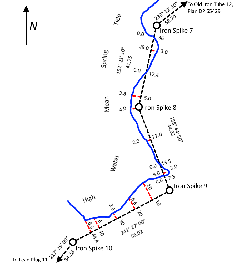
English: A simplified tracing of part of North Auckland Deposited Plan 79152 showing survey reference markers, traverse lines and offset measurements used to determine the location of a shoreline being used as a legal boundary line.
This work is based on/includes LINZ’s data which are licensed by Land Information New Zealand (LINZ) for re-use under the Creative Commons Attribution 3.0 New Zealand licence. |
| తేదీ | |
| మూలం | This work is based on/includes LINZ’s data which are licensed by Land Information New Zealand (LINZ) for re-use under the Creative Commons Attribution 3.0 New Zealand licence. |
| కర్త | Land Information New Zealand, Derivative work by TBP25 |
లైసెన్సింగ్
ఈ ఫైలు అనుమతి సాధారణ సృజనాత్మకము అపాదింపు ౩.౦ ఆన్-పోర్టెడ్ యందు అనుమతించబడినది.
- ఇలా చేసేందుకు మీకు స్వేచ్ఛ ఉంది:
- పంచుకోడానికి – ఈ కృతిని కాపీ చేసుకోవచ్చు, పంపిణీ చేయవచ్చు, ప్రసారమూ చేయవచ్చు
- రీమిక్స్ చేయడానికి – కృతిని అనుకరించడానికి
- క్రింది షరతులకు లోబడి:
- ఆపాదింపు – సముచితమైన శ్రేయస్సును ఇవ్వాలి, లైసెన్సుకు లింకు ఇవ్వాలి, మార్పులేమైనా చేస్తే వాటిని సూచించాలి. అందుకు సముచితమైన పద్ధతి దేన్నైనా అవలంబించవచ్చు. కానీ మీకూ మీ వాడుకకూ హక్కుదారు అనుమతించారు అనే అర్థం వచ్చేటట్లుగా మాత్రం కాదు.
ఫైలు చరితం
తేదీ/సమయం ను నొక్కి ఆ సమయాన ఫైలు ఎలా ఉండేదో చూడవచ్చు.
| తేదీ/సమయం | నఖచిత్రం | కొలతలు | వాడుకరి | వ్యాఖ్య | |
|---|---|---|---|---|---|
| ప్రస్తుత | 09:32, 23 జూలై 2014 | | 893 × 1,000 (109 KB) | TBP25 | Colour coded - red lines are offset measurements |
| 12:28, 18 జూలై 2014 |  | 893 × 1,000 (109 KB) | TBP25 | User created page with UploadWizard |
లింకులు
కింది పేజీలలో ఈ ఫైలుకు లింకులు ఉన్నాయి:
సార్వత్రిక ఫైలు వాడుక
ఈ దస్త్రాన్ని ఈ క్రింది ఇతర వికీలు ఉపయోగిస్తున్నాయి:
- en.wikipedia.org లో వాడుక
- ja.wikipedia.org లో వాడుక