అమెజాన్ నది
| Amazon River [Rio Amazonas] Error: {{Lang}}: invalid parameter: |3= (help) | |
|---|---|
 Amazon River | |
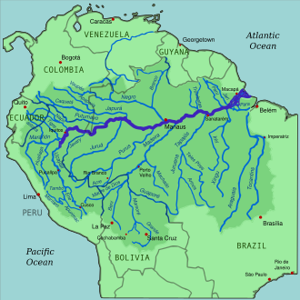
 Amazon River and its drainage basin | |
| స్థానిక పేరు | [Amazonas (Portuguese)] Error: {{Native name}}: missing language tag (help) (language?) |
| స్థానం | |
| Country | Peru, Colombia, Brazil |
| City | Iquitos (Peru); Leticia (Colombia); Tabatinga (Brazil); Tefé (Brazil); Itacoatiara (Brazil) Parintins (Brazil); Óbidos (Brazil); Santarém (Brazil); Almeirim (Brazil); Macapá (Brazil); Manaus (Brazil) |
| భౌతిక లక్షణాలు | |
| మూలం | Río Apurimac, Mismi Peak |
| • స్థానం | Arequipa Region, Peru |
| • అక్షాంశరేఖాంశాలు | 15°31′04″S 71°41′37″W / 15.51778°S 71.69361°W |
| • ఎత్తు | 5,220 మీ. (17,130 అ.) |
| సముద్రాన్ని చేరే ప్రదేశం | Atlantic Ocean |
• స్థానం | Brazil |
• అక్షాంశరేఖాంశాలు | 0°42′28″N 50°5′22″W / 0.70778°N 50.08944°W[1] |
| పొడవు | 6,500 kమీ. (21,300,000 అ.)[n 1] |
| పరీవాహక ప్రాంతం | 7,000,000 kమీ2 (7.5×10¹³ sq ft)[2] 6,743,000 kమీ2 (7.258×10¹³ sq ft)[5] |
| వెడల్పు | |
| • minimum | 700 మీ. (2,300 అ.) (Upper Amazon); 1.5 kమీ. (0.93 మై.) (Itacoatiara, Lower Amazon)[6] |
| • average | 3 kమీ. (1.9 మై.) (Middle Amazon); 5 kమీ. (3.1 మై.) (Lower Amazon)[6][7] |
| • maximum | 10 kమీ. (6.2 మై.) to 14 kమీ. (8.7 మై.) (Lower Amazon);[6][8] 340 kమీ. (210 మై.) (estuary)[9] |
| లోతు | |
| • average | 15 మీ. (49 అ.) to 45 మీ. (148 అ.) (Middle Amazon); 20 మీ. (66 అ.) to 50 మీ. (160 అ.) (Lower Amazon)[6] |
| • maximum | 150 మీ. (490 అ.) (Itacoatiara); 130 మీ. (430 అ.) (Óbidos)[6][7] |
| ప్రవాహం | |
| • స్థానం | Atlantic Ocean (near mouth) |
| • సగటు | 215,000 m3/s (7,600,000 cu ft/s)–230,000 m3/s (8,100,000 cu ft/s)[10][11]
(Basin size: 5,956,000 kమీ2 (6.411×10¹³ sq ft)[12] 205,603.262 m3/s (7,260,810.7 cu ft/s)[13] (Basin size: 5,912,760.5 kమీ2 (6.3644424×10¹³ sq ft)[13] |
| • కనిష్టం | 180,000 m3/s (6,400,000 cu ft/s) |
| • గరిష్టం | 340,000 m3/s (12,000,000 cu ft/s) |
| ప్రవాహం | |
| • స్థానం | Amazon Delta, Amazon/Tocantins/Pará |
| • సగటు | 230,000 m3/s (8,100,000 cu ft/s)[5] (Basin size: 6,743,000 kమీ2 (7.258×10¹³ sq ft)[5] to 7,000,000 kమీ2 (7.5×10¹³ sq ft)[2] |
| ప్రవాహం | |
| • స్థానం | Santarém |
| • సగటు | 191,624.043 m3/s (6,767,139.2 cu ft/s)[13] |
| ప్రవాహం | |
| • స్థానం | Óbidos (800 km upstream of mouth - Basin size: 4,704,076 kమీ2 (5.063425×10¹³ sq ft) |
| • సగటు | 173,272.643 m3/s (6,119,065.6 cu ft/s)[13]
(Period of data: 1928-1996)176,177 m3/s (6,221,600 cu ft/s)[14] (Period of data: 01/01/1997-31/12/2015)178,193.9 m3/s (6,292,860 cu ft/s)[15] |
| • కనిష్టం | 75,602 m3/s (2,669,900 cu ft/s)[14] |
| • గరిష్టం | 306,317 m3/s (10,817,500 cu ft/s)[14] |
| ప్రవాహం | |
| • స్థానం | Manacapuru, Solimões (Basin size: 2,147,736 kమీ2 (2.311804×10¹³ sq ft) |
| • సగటు | (Period of data: 01/01/1997-31/12/2015) 105,720 m3/s (3,733,000 cu ft/s)[15] |
| పరీవాహక ప్రాంత లక్షణాలు | |
| ఉపనదులు | |
| • ఎడమ | Marañón, Nanay, Napo, Ampiyaçu, Japurá/Caquetá, Rio Negro/Guainía, Putumayo, Badajós, Manacapuru, Urubu, Uatumã, Nhamundá, Trombetas, Maicurú, Curuá, Paru, Jari |
| • కుడి | Ucayali, Jandiatuba, Javary, Jutai, Juruá, Tefé, Coari, Purús, Madeira, Paraná do Ramos, Tapajós, Curuá-Una, Xingu, Pará, Tocantins, Acará, Guamá |

The Amazon River (UK: /ˈæməzən/, US: /ˈæməzɒn/; స్పానిష్: [Río Amazonas] Error: {{Lang}}: text has italic markup (help), Portuguese: Rio Amazonas) in South America is the largest river by discharge volume of water in the world, and the disputed longest river system in the world in comparison to the Nile.[2][16][n 2]
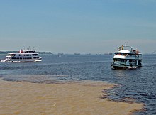
The headwaters of the Apurímac River on Nevado Mismi had been considered for nearly a century the Amazon basin's most distant source, until a 2014 study found it to be the headwaters of the Mantaro River on the Cordillera Rumi Cruz in Peru.[21] The Mantaro and Apurímac rivers join, and with other tributaries form the Ucayali River, which in turn meets the Marañón River upstream of Iquitos, Peru, forming what countries other than Brazil consider to be the main stem of the Amazon. Brazilians call this section the Solimões River above its confluence with the Rio Negro[22] forming what Brazilians call the Amazon at the Meeting of Waters (Portuguese: Encontro das Águas) at Manaus, the largest city on the river.

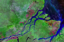
అమెజాన్ నది (English: Amazon River), దక్షిణ అమెరికాలోని పెద్ద నది. ఇది ప్రపంచంలోనే (పరిమాణంలో) అతి పెద్దనది (నైలు నది పొడవైనది). అమెజాన్ నదీప్రవాహం, ప్రపంచంలోని టాప్-10 నదుల నీటి ప్రవాహాలకన్నా ఎక్కువ. ప్రపంచంలోని అన్ని నదుల మొత్తం ప్రవాహంలో దాదాపు 5వ వంతు అమెజాన్ నదీ ప్రవాహమే. పెరూ దేశంలోని ఆండీస్ పర్వత శ్రేణుల్లో పుట్టే హొ ఆర్కో ఉసియాల్, మారానాన్ నదులు కలిసి అమెజాన్ నదిగా ప్రవహించి బెలెం అనే ప్రాంతంలో అట్లాంటిక్ మహాసముద్రంలో కలుస్తుంది.[23] దీని విశాలమైన నదీ ప్రవాహాన్ని దృష్టిలో పెట్టుకొని దీనికి "నదీ సముద్రం" (రివర్ సీ) అని వ్యవహరిస్తారు. ఈ నదీ పరీవాహక ప్రాంతాలలో వంతెనలైతే అసలు కానరావు. దీనిపై వంతెనలే లేవు. ఈ నది వెడల్పు ఎక్కువ వున్న కారణంగా, వంతెనలు నిర్మించలేక పోతున్నారు.[24] ఈ నదీ పరీవాహక ప్రాంతంలోగల ఋతుపవన అడవులలో, కొన్ని చోట్ల నగరాలు కానవస్తాయి, కొన్ని రోడ్లు కానవస్తాయి.
పొడవులో ఈ నది ప్రపంచంలో రెండవది. మొదటిది నైలు నది.
ఈ నది పెరు, కొలంబియా, బ్రెజిల్, బొలీవియా, వెనుజులా, ఈక్వెడార్, గయానా దేశాల గుండా ప్రవహిస్తూవుంది.

అమెజాన్ నదీ వ్యవస్థలో పెద్ద నదులు
[మార్చు]- 6,992 కి.మీ. (3,969 mi) - అమెజాన్, దక్షిణ అమెరికా
- 3,379 కి.మీ. (2,100 mi) - :పురుస్, పెరూ / బ్రెజిల్, (2,948 కి.మీ.) (3,210 km) [ఆధారం చూపాలి]
- 3,239 km (2,013 mi) - మదీరా, బొలీవియా / బ్రెజిల్
- 2,820 km (1,752 mi) - యపూరా, కొలంబియా / బ్రెజిల్
- 2,750 km (1,709 mi) - టొకాంటిన్స్, బ్రెజిల్, (2,416 km) (2,640 km) [ఆధారం చూపాలి]
- 2,575 km (1,600 mi) - అరగైయా, బ్రెజిల్ (tributary of Tocantins)
- 2,410 km (1,498 mi) - జురువా, పెరు / బ్రెజిల్
- 2,250 km (1,398 mi) - నైగర్, దక్షిణ అమెరికా
- 2,100 km (1,305 mi) - జింగు, బ్రెజిల్
- 1,900 km (1,181 mi) - en:Tapajós, బ్రెజిల్
- 1,749 km (1,087 mi) - en:Guaporé, బ్రెజిల్ / బొలీవియా (tributary of Madeira)
- 1,600 km (1,030 mi) - ఉకయాలి నది, పెరు
- 1,575 km (979 mi) - ఇక్యా (పుటుమాయో), దక్షిణ అమెరికా
- 1,415 km (879 mi) - మరనోన్, పెరు / ఈక్వెడార్
- 1,300 km (808 mi) - ఇరిరి, బ్రెజిల్ (tributary of Xingu)
- 1,240 km (771 mi) - జురుయేనా, బ్రెజిల్ (tributary of Tapajós)
- 1,200 km (746 mi) - తపజోస్, బ్రెజిల్
- 1,130 km (702 mi) - మాడ్రె డె డియోస్, పెరు / బొలీవియా (tributary of Madeira)
- 1,100 km (684 mi) - హువల్లాగా, పెరు (మరనోన్ నదికి ఉపనది.)
ఇవీ చూడండి
[మార్చు]మూలాలు
[మార్చు]- ↑ Amazon River at GEOnet Names Server
- ↑ 2.0 2.1 2.2 2.3 2.4 2.5 "Amazon River". Encyclopædia Britannica. Archived from the original on 8 November 2020.
- ↑ 3.0 3.1 3.2 Liu, Shaochuang; Lu, P; Liu, D; Jin, P; Wang, W (1 March 2009). "Pinpointing the sources and measuring the lengths of the principal rivers of the world". Int. J. Digital Earth. 2 (1): 80–87. Bibcode:2009IJDE....2...80L. doi:10.1080/17538940902746082. S2CID 27548511. Archived from the original on 23 December 2018. Retrieved 29 December 2018.
- ↑ "Where Does the Amazon River Begin?". National Geographic News. 15 February 2014. Archived from the original on 27 March 2019. Retrieved 25 December 2018.
- ↑ 5.0 5.1 5.2 "CORPOAMAZONIA - TRÁMITES PARA APROVECHAMIENTO FORESTAL" (PDF). Archived from the original (PDF) on 2023-01-06. Retrieved 2023-01-10.
- ↑ 6.0 6.1 6.2 6.3 6.4 "Issues of local and global use of water from the Amazon".
- ↑ 7.0 7.1 "Seasonal assessment of groundwater quality in the cities of Itacoatiara and Manacapuru (Amazon, Brazil)".[permanent dead link]
- ↑ "Amazon River-Hidrology".
- ↑ "Aguas Amazonicas".
- ↑ Pierre, Ribstein; Bernard, Francou; Anne, Coudrain Ribstein; Philippe, Mourguiart (1995). "EAUX, GLACIERS & CHANGEMENTS CLIMATIQUES DANS LES ANDES TROPICALES - Institut Français d'Études Andines - Institut Français de Recherche Scientifique pour le Développement en Cooperation" (PDF). Archived (PDF) from the original on 2022-10-09.
- ↑ Seyler, Patrick; Laurence Maurice-Bourgoin; Jean Loup Guyot. "Hydrological Control on the Temporal Variability of Trace Element Concentration in the Amazon River and its Main Tributaries". Geological Survey of Brazil (CPRM). Archived from the original on 21 జూలై 2011. Retrieved 24 జూలై 2010.
- ↑ Jacques Callède u. a.: Les apports en eau de l'Amazone à l'Océan Atlantique. In: Revue des sciences de l'eau / Journal of Water Science. Bd. 23, Nr. 3, Montreal 2010, S. 247–273 (retrieved 19 August 2013)
- ↑ 13.0 13.1 13.2 13.3 "Rivers Network".
- ↑ 14.0 14.1 14.2 GRDC: Daten des Pegels Óbidos
- ↑ 15.0 15.1 Jamie, Towner (2019). "Assessing the performance of global hydrological models for capturing peak river flows in the Amazon basin" (PDF).
- ↑ Uereyen, Soner; Kuenzer, Claudia (9 December 2019). "A Review of Earth Observation-Based Analyses for Major River Basins". Remote Sensing. 11 (24): 2951. Bibcode:2019RemS...11.2951U. doi:10.3390/rs11242951.
- ↑ ఉల్లేఖన లోపం: చెల్లని
<ref>ట్యాగు;britannica-nileఅనే పేరుగల ref లలో పాఠ్యమేమీ ఇవ్వలేదు - ↑ ఉల్లేఖన లోపం: చెల్లని
<ref>ట్యాగు;bbc-amazonఅనే పేరుగల ref లలో పాఠ్యమేమీ ఇవ్వలేదు - ↑ Roach, John. "Amazon Longer Than Nile River, Scientists Say". National Geographic. Archived from the original on 15 August 2012. Retrieved 4 March 2015.
- ↑ "How Long Is the Amazon River?". Encyclopedia Britannica (in ఇంగ్లీష్). Archived from the original on 24 December 2018. Retrieved 24 December 2018.
- ↑ James Contos; Nicholas Tripcevich (March 2014). "Correct placement of the most distant source of the Amazon River in the Mantaro River drainage" (PDF). Area. 46 (1): 27–39. doi:10.1111/area.12069.
- ↑ Penn, James R. (2001). Rivers of the World. ABC-CLIO. p. 8. ISBN 978-1-57607-042-0.
- ↑ బుడ్డిగ సుబ్బరాయన్ (1990). బాలల విజ్ఞాన సర్వస్వము - సంస్కృతి విభాగము (in Telugu).
{{cite book}}: CS1 maint: unrecognized language (link) - ↑ "Amazon (river)" (2007 ed.). Microsoft Encarta Online Encyclopedia. Archived from the original on 2009-10-29. Retrieved 2007-08-12.
బయటి లింకులు
[మార్చు]- Amazon dries up Youtube (31 July 2006)
- Bibliography on Water Resources and International Law Peace Palace Library
- Information on the Amazon from Extreme Science
- Pictures of the Amazon River
- Information and a map of the Amazon's watershed
- Amazon Alive: Light & Shadow documentary film about the Amazon river
ఉల్లేఖన లోపం: "n" అనే గ్రూపులో <ref> ట్యాగులు ఉన్నాయి గానీ, దానికి సంబంధించిన <references group="n"/> ట్యాగు కనబడలేదు
- మూలాల లోపాలున్న పేజీలు
- All articles with dead external links
- CS1 maint: unrecognized language
- Articles containing Portuguese-language text
- Pages using Lang-xx templates
- Articles containing English-language text
- March 2007 నుండి మూలాలు చేర్చవలసిన పాఠ్యమున్న వ్యాసాలు
- Commons link is locally defined
- నదులు
- భూగోళశాస్త్రం
